
Dehat by Definition
India’s Census sorts every place into one of two boxes, village or town. Many of the country’s most crowded places fit neither.
Spatial India
[written by]

Spatial India puts India's public data on one map, so questions about India become evidence you can compare and cite. We find official data, clean it and line it up, so researchers, journalists and analysts don't have to.
Gandhi’s villages, Ambedkar’s individual
Writing in Young India in March 1925, MK Gandhi said that India’s way was not Europe’s. “India is not Calcutta and Bombay. India lives in her seven hundred thousand villages.”1 He was replying to a revolutionary, and he told such men to “spread out into these villages and try to bring sunshine into the dark dungeons of the millions of their countrymen.” The line soon outgrew the letter it appeared in: generations of political leaders have since quoted it as proof that the real India lives in its villages.
BR Ambedkar answered from the opposite side. Speaking in the Constituent Assembly on 4 November 1948, he said: “I hold that these village republics have been the ruination of India. What is the village but a sink of localism, a den of ignorance, narrow-mindedness and communalism? I am glad that the Draft Constitution has discarded the village and adopted the individual as its unit.”2 ==He added that “the love of the intellectual Indians for the village community is of course infinite if not pathetic”, and the House laughed.==
The two men disagreed about what the village was worth, but both were describing the same kind of place: a settlement set apart from the town.
On the question of the unit, Ambedkar carried the day. The Constitution took the individual as its basis and placed village panchayats in Article 40, among the Directive Principles. Parliament returned to the question in 1992, when the 73rd and 74th Amendments gave panchayats and municipalities a constitutional footing of their own.3 The second amendment contains a line that few people read: Article 243Q provides for a Nagar Panchayat in “a transitional area, that is to say, an area in transition from a rural area to an urban area”.4
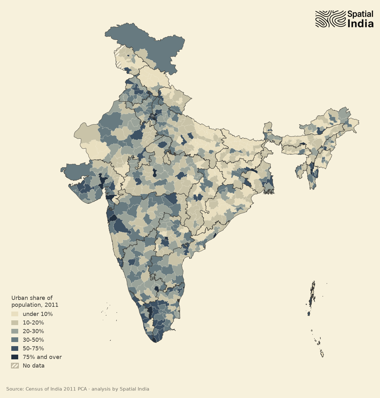
The Constitution, then, recognises three kinds of place: the village, the town, and the area in transition between them. The Census recognises only two. In 2011 it counted 68.8% of Indians as rural.5 Repeated in newspaper editorials and on social media, this figure keeps alive the old idea of India as a nation of villages. Behind it sits a single census rule.
This essay is about that rule. Many of India’s crowded places fit neither of its two boxes: they are as dense as towns, but the Census’s work test keeps them rural on paper. India needs a third category for these areas in transition, one measured by the density of built-up land and by every worker.
seventy lakh townspeople who never moved
In 2011, about seventy lakh people in Kerala became town-dwellers without moving house. The Census had reclassified their villages as census towns.6 Over that decade Kerala’s population grew by less than 5%, yet its urban share nearly doubled, from 26% to 48%.7 The road from Thrissur to Kozhikode shows what the Census had caught up with.
For most of the way, houses and shops run into one another, with schools, clinics and bus stops in between, and open fields are hard to find. Many of these places had looked like towns for years before the Census counted them as towns. In much of the rest of India, comparable places are still counted as villages.
Dehati is a word every Indian understands. Strictly it means someone from the countryside. It usually carries a second meaning too: provincial, a step behind whoever happens to be speaking. It calls up a picture of quiet villages where everyone farms. The places in this essay look nothing like that. In one block of Murshidabad, 98% of working women work off the farm. In rural Bihar, several districts have more than 1,600 people to the square kilometre, crowded by any standard. Neither fits the picture, yet the Census counts both as villages.
Why? Because of a short census rule that decides what counts as urban.
three tests, met simultaneously
The Census recognises two kinds of town. A statutory town is one with a municipal body of some sort. Any other place is rural unless it passes a test, and a place that passes becomes a census town. To pass, it has to meet three criteria “simultaneously”, to use the Census’s own word: at least 5,000 people, at least 400 persons per square kilometre, and “at least 75 per cent of the male main working population” in non-agricultural work.8 A place that misses on any one of them stays a village, however it looks on the ground.
The rule began as a reform. Before 1961, as the Census later put it, some princely states “were inclined to treat any village with a lamp post as an urban centre!”9 The 1961 Census set firm thresholds so that India would have “a list of urban areas in 1961 that would form a series for the future”.10 Its work test asked that three quarters of all workers be outside agriculture. The 1971 Census narrowed this to male workers,11 and ten years later fishing and logging were counted as agriculture, while women stayed outside the criteria.12
Keeping one rule this long has a real benefit. Because the test in use today dates from 1981, a researcher comparing 1981 with 2011 knows that a shift in the figures reflects a shift on the ground.
The cost of that stability falls on the places themselves. A census town is urban only in the statistical tables: it has no municipality, a gram panchayat (the village council) governs it as it would any village, and about two thirds of census towns have no master plan.13 The test is also run on old figures: the census towns of 2011 were chosen on 2001 data, so each list describes places as they stood a decade earlier.14
what happens when women are counted
The work test has two blind spots. It has counted only men since 1971, and only main workers (people who worked for six months or more of the year before the census) since 1981. Imagine a place where the men farm and the women roll bidis for a contractor: the Census records it as a village, because the women’s work is left out of the calculation.
We expected that counting women would make India look more urban. For most of the country, the 2011 figures show the opposite. A little under a third of rural India’s male main workers (31.4%) worked outside agriculture. Add the women, along with the marginal workers who worked less than six months of the year, and the share for all rural workers drops to 27.7%; it falls in 487 of 631 districts.15 Rural women who work, in other words, are more likely than rural men to work in the fields.
But the national average hides two quite different patterns, and two districts show them.
Murshidabad in West Bengal is bidi country. Four in five rural women workers there work off the farm, and household industry alone employs half of the district’s rural women workers. Most of its rural men, by contrast, farm. In the district’s Suti-II block, 98% of working women work off the farm, and counting them, together with the marginal workers, doubles the block’s non-farm share from 32% to 64%.16 The zari and attar towns of Kannauj and Farrukhabad in Uttar Pradesh show the same pattern, as do Nizamabad in Telangana and Tirunelveli in Tamil Nadu. In each, much of the work is household industry: bidi, zari, attar.
Hamirpur in Himachal Pradesh shows the reverse. Nearly three quarters of its rural male main workers are off the farm, which puts the district close to the urban line, but most rural women there work the terraced fields. When everyone is counted, the non-farm share falls from 72.5% to 33%.17
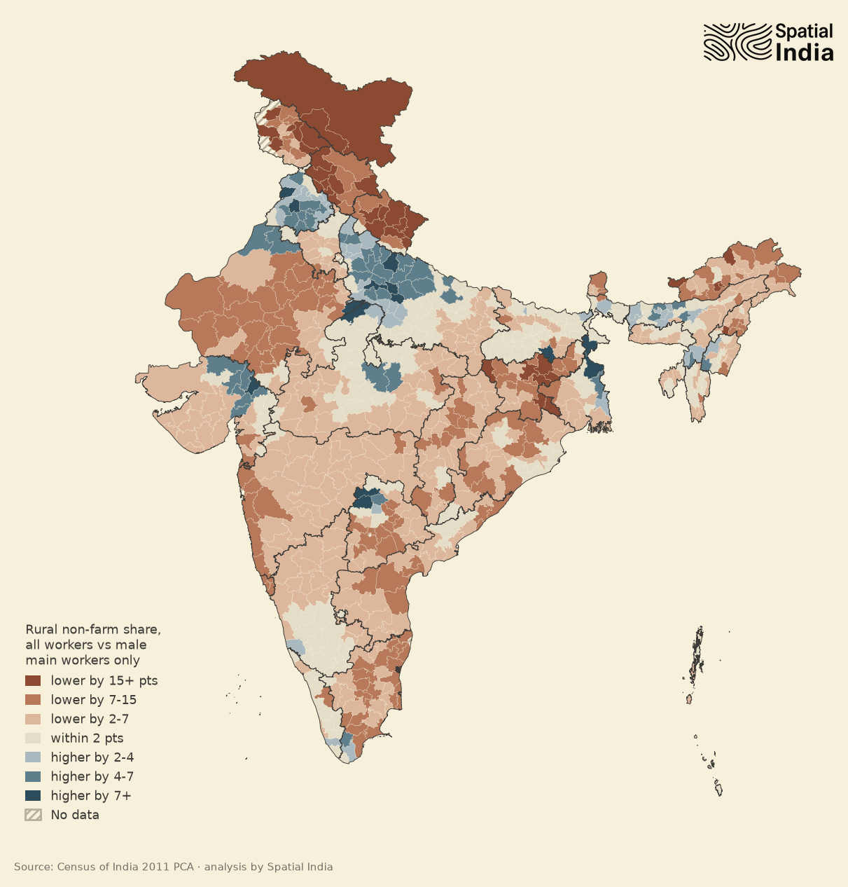
The male clause, then, is inaccurate: it overstates non-farm work in Hamirpur and understates it in Murshidabad. The Ministry of Housing and Urban Affairs made the same point to the Registrar General in February 2024. The Ministry questioned the “male bias” of the rule and said that “the female workforce participation should also be utilised”.18 Counting every worker would correct both errors, and on the 2011 figures it would leave the country looking more agricultural: among census towns, 268 would fail the work test and 34 would newly pass. A looser rule, under which a place passes if either its men or its women reach 75%, would lift the bidi belt and leave Hamirpur where it is. It would add 104 rural sub-districts with 1.85 crore people, and in about half of them women are under a fifth of the workers.19
Counting women makes the test fairer, but it does not settle how urban India is. That depends on density.
31% urban, or 63%?
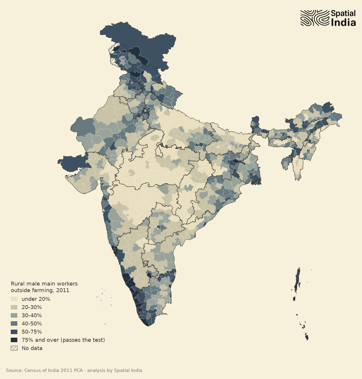
We cannot recompute India’s official urban share from district figures; that would need numbers for every village. What district data can show is where the label on a place and the way its people live have come apart. One caveat runs through everything below. The Census reports workers in four broad categories, and these put some fishing, plantation and dairy work on the non-farm side, even though the test itself counts it as farming. Our non-farm figures therefore run a little high.20
Taken district by district, almost no countryside passes the work test. Rural Kerala is the leading exception, clearing 75% by less than half a point even on those generous categories. Six Kerala districts have rural areas at or above both thresholds, and so does Dhanbad, the coal district. Go down a level and 273 rural sub-districts, with 2.75 crore people between them, reach 75% on work.21 Anyone running a village-level check should start there.
Density is a different matter: it seldom keeps a place rural. We counted 131 present-day districts that are under 20% urban and yet pack more than 400 people into each square kilometre of countryside. Between them they hold 27 crore rural people, most of them in Bihar and eastern Uttar Pradesh, the rest in West Bengal and Assam.22 Rural Vaishali in Bihar is packed tighter still, at 1,676 or more to the square kilometre, and most of its men still farm.
This is why the satellites and the Census tell such different stories. By the Census, India was about 31% urban in 2011.5 The Economic Survey 2025-26 cites a UN estimate, built from European satellite data, that put the figure at 63% in 2015.23 The two figures are four years apart, but one is double the other, far too large a gap to be a rounding error. Read by density, the crowded Gangetic plain turns urban, and India flips from a mostly rural country to a mostly urban one.
None of the higher estimates applies a work test. The UN figure counts people by density and settlement size, and the World Bank adds travel time to a city. One gridded-population study says outright that it ignores the Census’s “gender and economic activity thresholds”.24 Researchers at the Indian Institute for Human Settlements ran the census tests one at a time on 2001 village data. Density alone would have made India 69% urban, and the work test alone 34%. In Uttar Pradesh, Bihar, West Bengal and Madhya Pradesh, the work test was what kept large, dense settlements rural.25
Nor is the male clause what drives the gap. On our sub-district figures, rewriting it in either direction moves fewer than two crore people.26 The gap between 31% and 63% turns on a larger question: whether a crowded village where most people farm is a town.
In 2018 a World Bank team checked locations by combining human judgment with machine learning, and its verdict sits much closer to the Census. ==India, they wrote, is “not substantially more urban” than the Census says, but “a considerable number of locations are misclassified in the midrange between villages and state capitals”.==27 So neither number settles it.
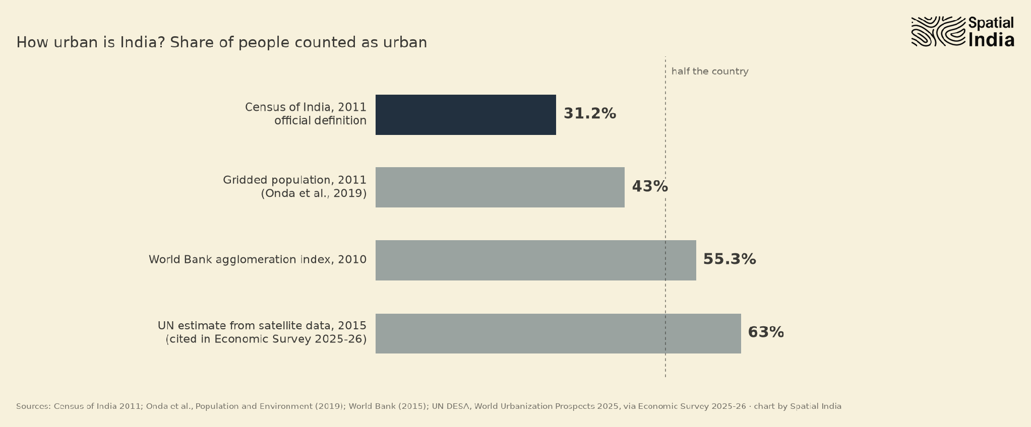
That midrange takes in Kerala’s coast as well as Bihar’s crowded plain: places the Census mostly counts as villages and the density methods count as cities. The better answer is that they are neither. In Bihar, they are as crowded as towns, but too few of their men work off the farm to pass the work test. In rural Kerala, most working men already do. Two boxes force a verdict on them; a third category would let them be what they are.
from swades to saubhagya
Twenty years ago, electricity reaching a village was the sort of thing that happened in films. In Swades (2004), an engineer home from NASA brings it to the village of Charanpur.
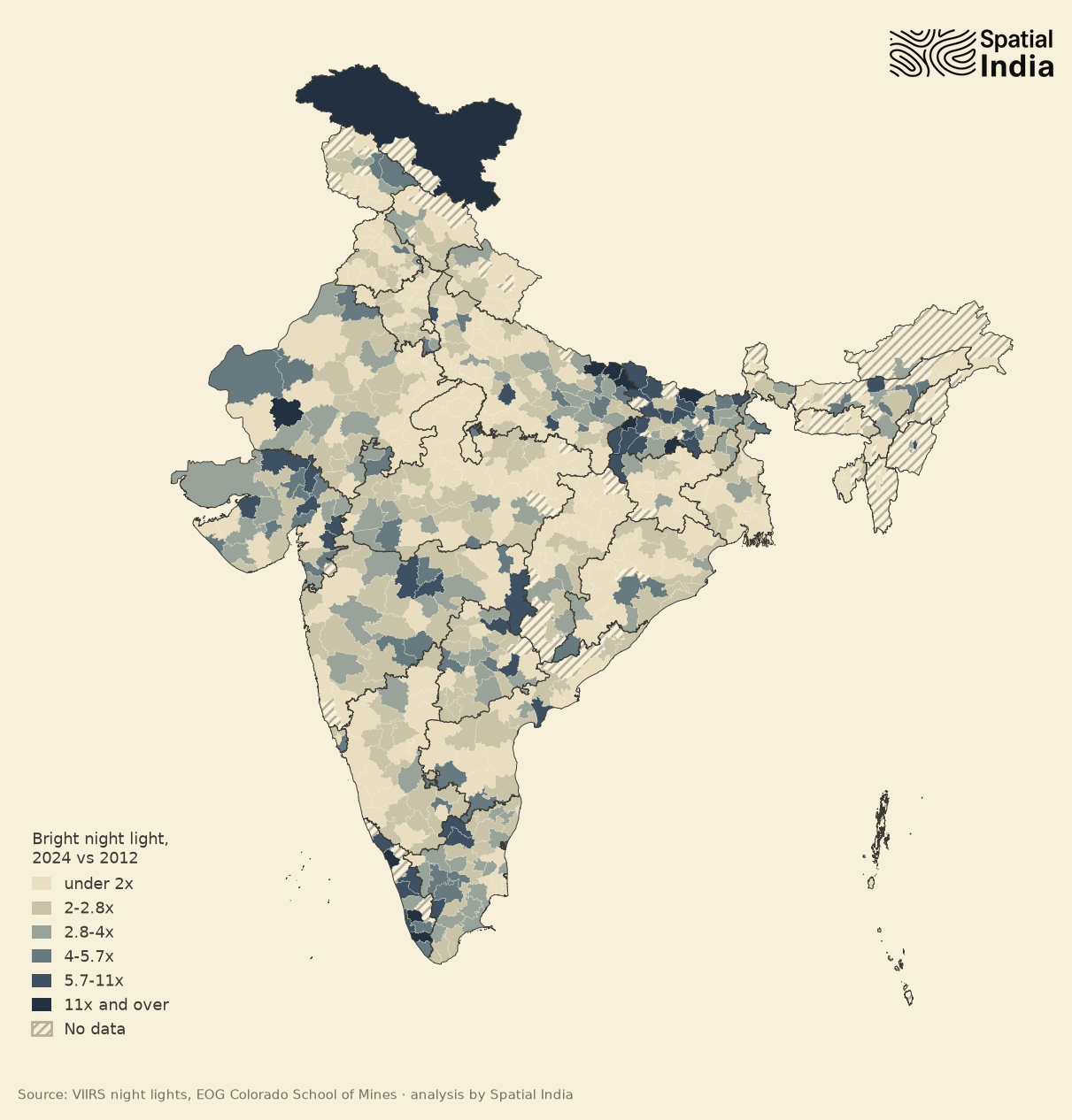
Night-time satellite images record what came after. Between 2012 and 2024, bright light grew faster in Kushinagar, Siddharthnagar and Mahrajganj in Uttar Pradesh and Madhubani and Nawada in Bihar than in almost any other district. All five are farming districts of the Gangetic plain, and across districts the growth has little to do with non-farm work.28 The timing points instead to the grid.
Leisang in Manipur, the last inhabited census village without power, was declared electrified on 28 April 2018, and the Ministry of Power reports 2.86 crore households connected under Pradhan Mantri Sahaj Bijli Har Ghar Yojana (Saubhagya).29 Seen from orbit, these villages are changing quickly.
That is what transition looks like from above: places changing in ways that the work test, which reads only occupation, cannot register.
a name for the places in between
Census 2027 is already under way. House-listing finished in September 2026, and most of India will be counted in February 2027.30 In August 2025, the Registrar General informed the state census directorates that the 2011 definition of an urban area would be kept, “as this will ensure comparability with the previous Census”.31 With enumerators already in the field, that is the right decision for this census.
Within the Government, though, the case for a new definition has been building for a decade.32 In March 2026, the Prime Minister’s Economic Advisory Council argued that the focus on the male workforce “renders this metric detached from today’s reality”.33 On 16 September 2026, the Ministry of Housing and Urban Affairs told a parliamentary committee that the old criteria cannot capture the real scale of India’s urbanisation. The Ministry favours measuring density on built-up land, with a separate category for areas in transition. The Registrar General’s reply made a fair point: the Ministry had not offered “an objective and quantifiable alternative definition”.18
Producing that alternative is a job for the coming decade. The 2027 count can keep its comparable series and still provide the base for a second classification. That classification would add a third category for places in transition, measured by density where people actually live and by every worker, women and part-year workers included. If the two were published side by side, the next census could change its rule without a jolt like the one Kerala’s figures gave in 2011.
Hindi and Urdu already have a word for such a place: qasba, the small market town, bigger than a village and short of a city. The Constitution has its own phrase, the area in transition. ==Only the Census lacks a name.==
When the rule was written, India had fewer than 44 crore people.34 The India counted in 2027 will be more than three times as large, and crores of its people live in the mofussil, the provinces beyond the big cities, in places the rule was never designed to see. The Constitution calls them areas in transition, and the census after this one has the chance to count them as such.
works discussed
-
M. K. Gandhi, “Notes: To Another Revolutionary”, Young India, 12 March 1925; The Collected Works of Mahatma Gandhi, vol. XXVI, p. 286. ↩
-
B. R. Ambedkar, “Motion re. Draft Constitution”, Constituent Assembly Debates (Official Report), vol. VII, 4 November 1948, p. 39. ↩
-
The Constitution (Seventy-third Amendment) Act, 1992, inserting Part IX (Panchayats), and the Constitution (Seventy-fourth Amendment) Act, 1992, inserting Part IXA (Municipalities). ↩
-
Constitution of India, Article 243Q(1)(a). ↩
-
Kanhu Charan Pradhan, “Unacknowledged Urbanisation: The New Census Towns of India”, Economic & Political Weekly, 48(36), 7 September 2013, pp. 43–51. Of Kerala’s 76.7 lakh new urban residents in 2001–11, 93% (about 71 lakh) lived in villages reclassified as census towns (p. 45); the state’s census towns went from 99 to 461. Across India they rose from 1,362 to 3,894 and account for 29.5% of the decade’s urban growth. 1,793 of the new ones already met all three tests in 2001. ↩
-
Census of India, Primary Census Abstract, Kerala. Urban share: 25.96% in 2001 (82.7 lakh of 3.18 crore) and 47.70% in 2011 (1.59 crore of 3.34 crore), while population grew 4.9%. Thrissur district went from 28.22% to 67.17% (District Census Handbook). ↩
-
Ministry of Home Affairs, Lok Sabha Unstarred Question No. 6458, answered 7 May 2013, Annexure II. The same criteria appear in C. Chandramouli, Census of India 2011: Rural Urban Distribution of Population (Provisional Population Totals), presentation, New Delhi, 15 July 2011, slides 10–11. ↩
-
Registrar General of India, Census of India 1971, Series 1, India, Paper 1 of 1971, Supplement: Provisional Population Totals, ch. II, “Urbanisation”. ↩
-
Registrar General of India, Census of India 1961, Vol. I, India, Part II-A(i), General Population Tables (1964), “Towns, Town Groups and Cities”, p. 51: “three-fourths of the occupations of the working population should be outside of agriculture”. ↩
-
Census of India 1971, Paper 1 of 1971, Supplement: “at least 75 per cent of male working population is non-agricultural” and “a density of population of at least 400 per sq. km. (i.e. 1,000 per sq. mile)”. ↩
-
MoSPI, Women and Men in India 2016, “Definitions and Explanations: Urban Area”. For Census 2027, cultivators, agricultural labourers and “plantation, livestock, forestry, fishing, hunting, and allied activities” are excluded from non-agricultural work (The Hindu, 23 August 2025). ↩
-
NITI Aayog, Reforms in Urban Planning Capacity in India, September 2021, pp. 18 and 33. ↩
-
Census of India 2011, Kerala, Series 33, Part XII-A, District Census Handbook, Thrissur, “Rural-Urban area” and the analytical note on urbanisation. Villages were considered on the basis of their population, density and male workforce “as per the 2001 Census”. ↩
-
Spatial India analysis of the Census 2011 Primary Census Abstract (district, sub-district and town level). Rural non-farm share: 31.4% of male main workers, 27.7% of all workers; in rural Kerala, 75.4% of male main workers. Method for all Spatial India notes: “non-agricultural” means household industry plus other workers. The official test counts plantation, livestock, forestry and fishing as agricultural, but the Census’s four-way split files them under other workers, so these shares overstate non-farm work a little. Rural density is rural population ÷ total district area, which understates it; sub-district area isn’t published, so density is tested only by district. Counts comparing women and men use the 640 districts of 2011 (631 with rural population); other counts use today’s districts, with the 35 created since 2011 taking their parent’s shares. ↩
-
Spatial India analysis. Rural Murshidabad: 80.5% of women workers are non-farm (49.9% in household industry), against 31.9% of male main workers. ↩
-
Spatial India analysis. Rural Hamirpur, Himachal Pradesh: 72.5% of male main workers are non-farm, but only 33% of all workers (men and women, main and marginal). ↩
-
Sobhana K. Nair, “Old Census town criteria will not capture India’s urbanisation, Ministry tells House panel”, The Hindu, 16 September 2026. ↩ ↩2
-
Spatial India analysis. Either-gender test: a place passes if its male main workers or its women workers (main and marginal) are at least 75% non-farm. Rural sub-districts passing the work test: 273 under the census rule, 183 counting all workers, 377 under the either-gender test. That last adds 104 sub-districts with 1.85 crore people; in 52 of them women are under 20% of workers. Census towns: 268 pass the male test but fail on all workers; 34 do the reverse. ↩
-
Spatial India analysis. The four broad worker categories file plantation, livestock, forestry and fishing under non-farm work, so they slightly overstate it against the test itself. ↩
-
Spatial India analysis: 273 rural sub-districts pass under the census rule, 183 if all workers are counted. ↩
-
Spatial India analysis, using today’s districts. Rural density is rural population ÷ total district area, so it understates true rural density. ↩
-
Economic Survey 2025-26, ch. 15, “Urbanisation”, para 15.10 and Box XV.1, pp. 591–596. Its 63% figure is UN DESA’s (World Urbanization Prospects 2025, Degree of Urbanisation method on the Global Human Settlement Layer). Other estimates: 43% for 2011 (gridded population, 7.5 persons per hectare) and 55.3% for 2010 (World Bank agglomeration index). ↩
-
Takahiro Onda et al., “Missing millions: undercounting urbanization in India”, Population and Environment, 2019. The study puts India at 43% urban in 2011, at a threshold of 7.5 persons per hectare. ↩
-
Arindam Jana, Neha Sami and Jessica Seddon, “How ‘urban’ is India?”, Indian Institute for Human Settlements, presentation for the International Growth Centre, 2014, slides 6, 8 and 28. ↩
-
Spatial India analysis of rural sub-districts passing the work test: 273 under the census rule, 183 counting all workers, 377 under the either-gender test. ↩
-
Virgilio Galdo, Yue Li and Martín Rama, “Identifying Urban Areas by Combining Human Judgment and Machine Learning: An Application to India”, World Bank Policy Research Working Paper 8628, 2018. ↩
-
Spatial India analysis of VIIRS annual night-time lights (Earth Observation Group, Colorado School of Mines): VNL v2.1 for 2012 (April 2012–March 2013) and v2.2 for 2024, summed over pixels brighter than 5 nW/cm²/sr. Only bright light is compared, since the two versions treat faint light differently. Across 642 districts, growth in bright light has a weak negative rank correlation (−0.08) with the rural male non-farm share. ↩
-
Press Information Bureau, “PM interacts with beneficiaries of Rural Electrification and Saubhagya Schemes across the country through video bridge”, 2018; Ministry of Power, “Saubhagya electrification scheme: a total 2.86 crore households have been electrified”, PIB, 2023. Both figures are as reported by the states. ↩
-
Gazette of India, S.O. 2681(E), 16 June 2025, superseded by S.O. 4919(E), 5 September 2026, which moves enumeration in Goa, Uttar Pradesh, Punjab and non-snow-bound Uttarakhand to 1 December 2026 – 4 January 2027. PIB, 30 March 2026: reference date 1 March 2027; 4,580 census towns in the frame as of 1 January 2026. ↩
-
Vijaita Singh, “Census 2027 to retain 2011 Census definition of an urban area”, The Hindu, 23 August 2025, quoting the Registrar General’s letter of 14 August 2025 to the State Directorates of Census Operations. ↩
-
In 2016 the Ministry of Urban Development asked 28 states to convert 3,784 census towns into urban local bodies. NITI Aayog noted in 2021 that several studies had found the current definitions “are not reflective of the extent of urbanization that the country has already witnessed”. The Economic Survey 2025-26 recommends satellite tools as a complement to the Census. The Sixteenth Finance Commission recommended a ₹10,000 crore grant for merging peri-urban villages into cities and framing a rural-to-urban transition policy (report tabled 1 February 2026). ↩
-
Shamika Ravi, Manuj Joshi and Apurv Kumar Mishra, India’s Hidden Urbanisation & Its Policy Implications, EAC-PM Working Paper 44, March 2026, p. 11. ↩
-
Census of India 1961, General Population Tables: 439,234,771 people. ↩